LURPA > Previous organization > Geo3D team
Consistency assurance of the acquired data (registration, data merging, partitioning)
The preprocessing stage is an essential preliminary step of any use of the data aquired in a multisensor context. Thus, the consistency assurance of the data acquired through registration, data merging and partitioning methods becomes an indispensable prerequisite for the utilization of digitized data.
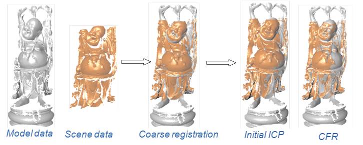
Registration
Registration is one of the most important steps of multisensor integration. A registration method with no a priori correspondence was developed. Here, a combination of the discrete curvature and the Euclidian distance is proposed as a performance improvement over the classical ICP registration algorithm.
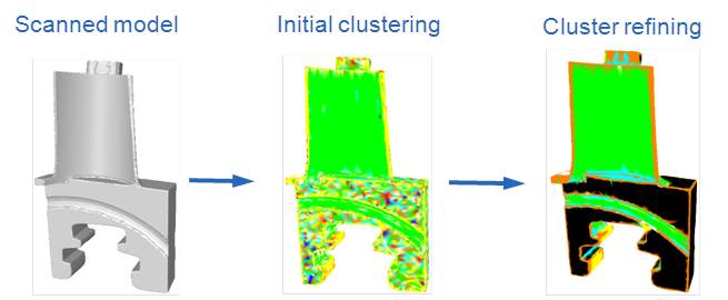
Identification of characteristic lines and segmentation
A new method, based on the shape index and curvedness, is being developed for the recognition and segmentation of discrete shapes.
In addition, a new approach for the identification of the bend lines and the partitioning of a point cloud obtained from a laser-plane sensor was also implemented as part of a collaborative project. The idea, taken from what is known as the "scale-space" method, consists in processing the point cloud on different scales. Thus, it is possible to benefit from the advantages of each scale being studied. Large scales make the treatment of dense local information easier while small scales enable the data related to the global geometry of the digitized part to be saved.
In addition, a new approach for the identification of the bend lines and the partitioning of a point cloud obtained from a laser-plane sensor was also implemented as part of a collaborative project. The idea, taken from what is known as the "scale-space" method, consists in processing the point cloud on different scales. Thus, it is possible to benefit from the advantages of each scale being studied. Large scales make the treatment of dense local information easier while small scales enable the data related to the global geometry of the digitized part to be saved.
Équipe de rattachement
Publications
- Publications sur 5 ans (depuis 2008)
- Publications antérieures (jusqu'à 2007)